|
Click on one of the following topics to jump to that section:
|
|
How to use the Bing Maps:
|
Here you will see Microsoft's up-to-date map detail and imagery from Bing combined with county GIS data
and sales transactions to give you more robust mapping features. Below you will see more detail about what the options on the blue bar will allow you to do.
|
Using the Navigation Buttons
|
The navigation buttons are on the left and include a compass and zoom options
Click on any of the arrows on the compass to move the map in that direction.

|
Click on the magnifying glass with the + sign to zoom in on the map or the magnifying glass with the - sign to zoom out.

|
Using the Viewing Options

|
The system will default to a 2D Aerial view with Layers. Click on the viewing options above the map to (from left to right):
|
- 2D - This is the default view which will show you the map in a 2 dimensional format.
- 3D - This option will prompt you to download the Microsoft Bing application that will allow you to view and navigate images in 3 dimensions.
- Road - This option will remove the aerial photo and show you a property map with street names.
- Aerial - This is the default view which shows you an Aerial photo perspective.
- Bird's Eye - This will change from the Aerial photo perspective to a Bird's Eye perspective. (Layers are not available in this view).
- CRS Layers - This option will allow you to add layers based on data from the PowerTool. These include:
- Parcels - will display parcel outlines
- Recent Sales - will shade the parcels which recently sold. You have the option of displaying sales from the last 3 months up to the last 2 years.
- Labels - will display labels on the parcels for: Deeded Acreage, System Calculated Acreage, Lot Dimensions, Owner Name, Street Number, Parcel ID, Last Sale Price & Date.
- FEMA - turn on the different FEMA layers to evaluate your subject property. *See below for more information about FEMA layers.
- My Measurements - this will allow you to turn on or off any measurements you have made while viewing the map during the current session.
- Subject Property - will hide or display the house icon on the subject property.
- Measure - You may measure the following on the map:
- Lon/Lat - will display the latitude and longitude for any point you choose.
- Distance - Use this tool to measure the length of any distance on the map. Click once on the map to start a measurement and click each time you want to change directions. Click twice to obtain the distance measured.
- Area - This tool allows you to measure any area that is visible on the screen. Click once on the map to start a measurement and click each time you want to change directions. Double click to close the polygon and obtain the acreage measured.
- Search - This tool allows you to search the map for multiple properties.
- by Parcel - Use this tool to click on any parcel to display the Owner Name, Property Address, Last Sale Date, Last Sale Price, and a link to the Property Report.
- by Rectangle, by Polygon, by Radius - Use this tool to select a group of parcels. When you choose an option, on-screen directions will guide you through the steps.
- Arrows at the end of bar - Clicking on these arrows will collapse the View Options toolbar.
FEMA Layer Details
The FEMA layers are generated directly from the FEMA mapping servers; therefore, may load slower than other layers. Turning the FEMA layers on works the same as turning any other layer on in the Bing� Maps. The available layers are:
- Flood Hazard Zones - show insurance risk zones. For more information about Flood Hazard Zones, click here.
- Cross Sections - the basis for calculating Base Flood Elevation when used with the Flood Insurance Study for the community
- Base Flood Elevations (BFE) - the computed elevation to which floodwater is anticipated to rise during the base flood. The relationship between the BFE and a structure's elevation determines the flood insurance premium.
- Bench Marks - elevation reference marks in the vicinity of the floodplain to aid in data collection
- LOMR's - Letter of Map Revision - may change flood insurance risk zones, floodplain and/or floodway boundaries
- LOMA and LOMR-F - Letter of Map Amendment and Letter of Map Revision based on Fill
For additional details about these layers, click here.
Using the Search Tools
The Search tool gives you different ways to search the map for properties surrounding your subject property. You can then use the results to prospect or generate a results list.
- By Parcel - allows you to view information about a specific parcel and pull the property report. (Tip: you can also view this information by right-clicking on a parcel)
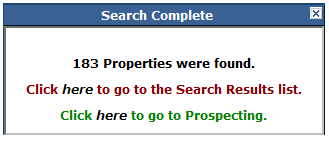
- By Rectangle - draw a rectangle over any area. Follow the onscreen prompts. Click on the map to start drawing then move your mouse until the rectangle covers the desired area. Click again to define the other corner of your rectangle. A green shaded rectangle will cover the selected area. When the search is complete, you will see a results box. (See below.)
- By Polygon - draw any shape to select your desired area. Click once to start drawing, click once to define any additional points. Double-click to end the polygon drawing. When the search is complete, you will see a results box. (See below.)
- By Radius - click on the map to start drawing a circle and drag the circle until the desired area is covered. Or, use the box in the lower right hand corner to define the radius in feet or miles. When the search is complete, you will see a results box. (See below.)
|
|
Note: When conducting these searches, you will be limited to 1000 search results.
The Search Results list option will take you to the Advanced Search result screen.
The Prospecting option will take you to the second step of the Prospecting tool where you can further define your target market.
|

